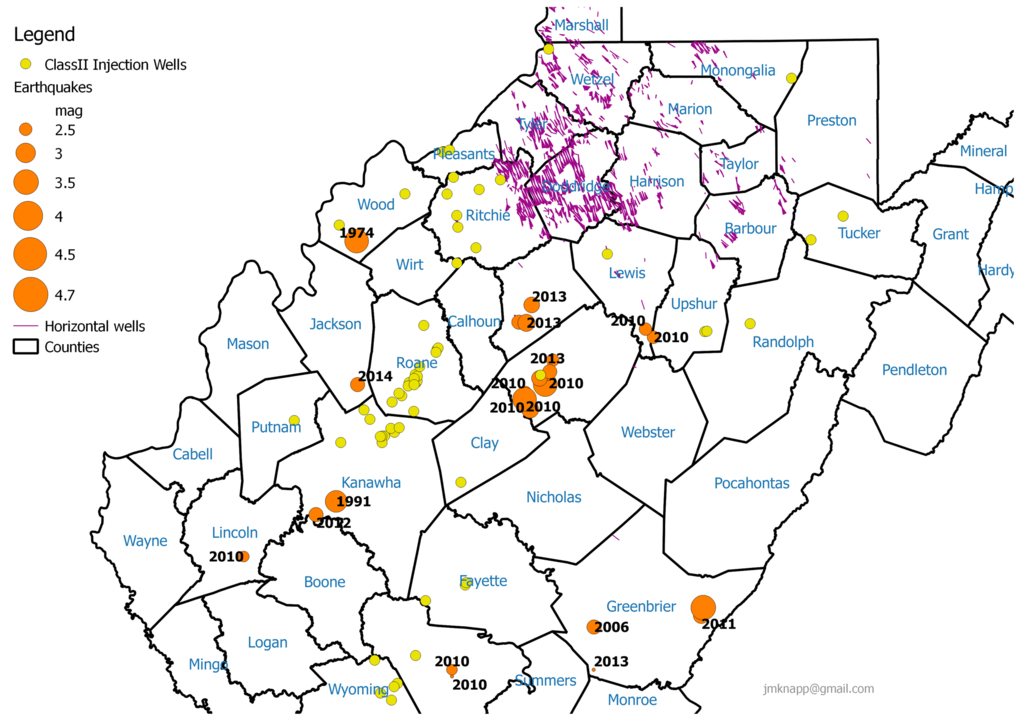
More fun with GIS data sets, this time looking at fracking and earthquake activity in West Virginia. The purple lines on the map above show the tracks of horizontal (fracking) wells, the data set coming from TAGIS:
Simplified Horizontal Well Laterals-- Features in this dataset are created as a single line segment drawn between top hole and bottom hole coordinates entered in the WVDEP database, based on coordinates supplied in the permit application.
The yellow dots show the locations of Class II injection wells, which are used dispose of waste liquid from oil and gas operations. The dataset was contributed on the ArcGIS web site.
The orange dots show the locations of earthquakes in the region from 1974 to present, from the USGS Earthquake Archives, the size indicating the strength of the quake. There are 41 quakes in this data set, over half of which have occurred in just the last six years.
The earthquake locations are more correlated with injection wells than horizontal wells. This closeup of an area with a lot of horizontal wells shows no earthquake activity over the period:

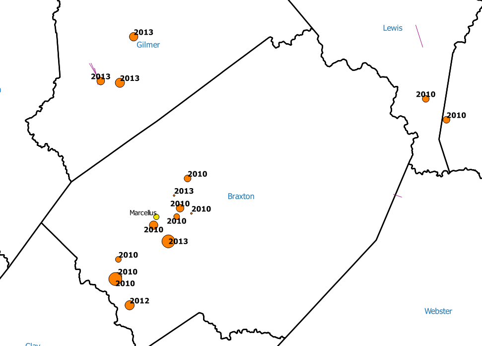
But recent earthquake activity has picked up in the vicinity of injection wells:
A closer view, with the year of occurrence of each quake shown, along with the formation that each injection well reaches.

Earthquakes have become more common with the proliferation of the injection wells. Of particular note is Braxton County which saw a flurry of small quakes in 2010 followed by a couple of magnitude 3 quakes, one in 2013. The injection well in Braxton County is very deep, reaching into the Marcellus shale formation.
A news item from 2012:
Small earthquake rattles Braxton near quake cluster recorded in 2010
Rick Steelhammer
FRAMETOWN, W.Va. -- A small earthquake was detected Tuesday in Braxton County, in the same general vicinity of a cluster of 10 similar-sized quakes that occurred in 2010.
"You could definitely feel it," Connie Sears, manager of Granny's Kitchen in Frametown, said Wednesday. "Everybody was talking about it today. People said that up the river closer to Gassaway, they could really feel it shaking."
According to the National Earthquake Information Center, the magnitude 2.8 earthquake took place at 2:39 p.m. Tuesday, with an epicenter about 10 miles west-southwest of Gassaway.
Between April and August of 2010, eight small earthquakes rattled through Braxton County, most of them in the Gassaway-Frametown area, and two more occurred just over the county line in Lewis and Upshur counties. Three of the quakes took place in a single day. The 2010 quakes ranged in intensity from magnitude 2.2 to 3.4.
A number of area residents, including Braxton Citizens' News publisher Ed Given, suspected that the source of the quakes was an underground injection well near Gassaway being used to dispose of brine and hydraulic fracturing fluids recovered from Marcellus Shale gas drilling. The injection well, located 1.5 miles up Lower Rock Camp Hollow, was used to dispose of more than 10.6 million gallons of brine and fracking fluids between March 2009 and June 2010.
Disposal fluids from the Rock Cave area are trucked to a storage and filtering facility along W.Va. 4 near the mouth of the hollow, and pumped to the injection well. The well had been licensed to inject the fluids into the ground at up to 2,100 pounds per square inch of surface pressure, but in an agreement with the Division of Environmental Protection, it was approved to substantially reduce the volume being injected. In August 2010, surface pressure at the well was reduced to about 200 pounds per square inch.
"At that time, we had looked into locating an array of seismometers to monitor activity around the well," and attracting some university's researchers to conduct a study based on data produced by the array, said Dr. Michael Hohn, director of the West Virginia Geological and Economic Survey.
"But late in 2010, the earthquakes stopped happening and people lost interest," Hohn said.
After a number of months passed with no additional seismic activity, the DEP allowed Chesapeake Energy to increase injection pressure at the Braxton disposal well.
But the use of injection wells to dispose of millions of gallons of water, brine and fracking fluids has been eyed as the possible source of earthquakes at a number of locations during the past several years.
In 2009, Chesapeake Energy shut down two brine disposal wells in the Dallas-Fort Worth, Tex., area, after a series of small earthquakes occurred in their vicinity. Cliff Frohlich, associate director of the University of Texas Institute for Geophysics, said at the time that use of the injection wells and the onset of earthquakes was related.
"We have not proven it with scientific certainty," he said in a Dallas Morning News article, "but we're looking at these as induced earthquakes."
Earlier this month, the Ohio Department of Natural Resources ordered disposal operations at an injection well near Youngstown to cease, after 11 earthquakes were recorded in its vicinity during the last week of December.
In the event that more seismic activity occurs in the vicinity of injection wells in West Virginia, "My hope is that a university would establish a research project," Hohn said. "It's becoming a topic of continued interest."